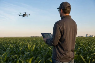


Residents of Freetown launched drones above the capital on May 28, 2026, to generate high-resolution maps through a community-led workshop.
The Humanitarian OpenStreetMap Team directed the session under its Scaling Open Drone Crews project. Operations began January 6, 2026, and now span seven West African cities including Freetown, Sierra Leone, and locations in Senegal.
Teams collected more than 130,000 images covering 75 km². Production costs stayed below $500 per km² because local residents handled flight operations and initial data review.
Approximately 100 Freetown residents completed drone pilot training. Another 35 municipal staff members learned processing workflows for the resulting geospatial datasets.
Our recent community-owned drone mapping initiative in Freetown produced high-quality drone imagery that was cost-effective and truly collaborative, involving women, youths, and persons with disabilities.
Alex Rivera, HOT Project Coordinator, issued that statement after reviewing workshop outputs. Documentation of the event appeared in posts from the Freetown Media Centre and an X account under the handle @barmmyboy.
Zag Daily also reported on the city-supported drone mapping effort. The coverage noted direct involvement of residents in every stage of image acquisition and verification.
Security agencies and municipal planners can apply the same low-cost imagery for infrastructure assessment, evacuation route verification, and crowd-density analysis in dense urban zones. The training model equips local crews to repeat flights on demand without external contractors.
Project leads expect the seven-city network to expand the pool of certified operators and standardized data pipelines. This approach reduces reliance on foreign imagery providers while maintaining technical standards suitable for law-enforcement mapping tools. Local authorities have praised the project for its inclusive approach and practical outcomes in urban planning and disaster preparedness.