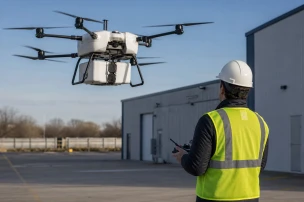


Corteva Agriscience has expanded its unmanned aerial operations into the world's largest commercial agricultural drone fleet, now exceeding 600 units integrated with DroneDeploy software for real-time data capture and analysis.
The collaboration originated in February 2019 through a global agreement that equipped an initial fleet of more than 400 DJI drones with DroneDeploy Live Map technology. This deployment supported systematic crop scouting across multiple continents by delivering immediate aerial imagery and field assessments to operators.
In February 2021 the partnership advanced when Corteva licensed its proprietary Stand Assessment artificial intelligence and machine learning models to DroneDeploy. The technology became available to U.S. agriculture customers, extending Corteva's internal capabilities into a broader commercial platform for stand counting and plant health evaluation.
Jeremy Groeteke, U.S. Digital Ag Lead at Corteva Agriscience, stated: "By collaborating with DroneDeploy, we can now help farmers efficiently scout their fields, provide data-driven analysis and insights around the products they need to use, consider opportunities to replant, and be more informed about their fields' performance."
The technical integration combines high-resolution mapping with machine learning algorithms that quantify crop density and identify replanting zones without manual field traversal. Fleet operators receive synchronized data streams that support rapid decision cycles on product application and resource allocation.
DroneDeploy's platform processes imagery captured by the Corteva fleet into layered geospatial outputs, enabling precise overlays of vegetation indices and treatment recommendations. This architecture demonstrates scalable command-and-control methods for coordinating hundreds of simultaneous UAV missions across dispersed operational areas.
Announcements from the DroneDeploy Blog and Corteva press releases confirm the fleet size progression and AI licensing terms. The resulting system illustrates large-scale UAV data pipelines that security and law enforcement agencies monitoring extensive perimeters or critical infrastructure may examine for operational parallels in real-time situational awareness.